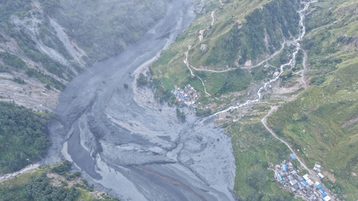
A sudden wall of water tore down a mountain valley in Nepal without any warning from heavy seasonal downpours. Early on a Sunday morning, the Budhi Gandaki River swelled past critical danger marks in the Gorkha district, wiping out over thirty-five homes, chewing through suspension bridges, and battering regional hydropower infrastructure before anyone had time to pack a bag.
When a river surges past five meters and climbs toward eight meters with zero preceding monsoonal storms, you know something structural went wrong high up in the Himalayas. Let's look at what actually happened during the Gorkha district flash flood, why standard weather forecasts missed it, and what this disaster reveals about the fragile geography of high-altitude river basins.
The Anatomy of a Dry Landslide Surge
Most mountain floods follow a predictable pattern. Heavy rain falls for days, soils saturate, and rivers spill over their banks. This disaster didn't follow that script.
Meteorological data from the area showed only sporadic, minor precipitation over the preceding twenty-four hours. Yet at six in the morning, sensors recorded an abnormal spike. Within two hours, water levels at the Budhigandaki-Arughat monitoring station rocketed past the five-meter danger mark, peaking at an astonishing 8.43 meters.
Satellite imagery and early field reports pointed to a specific mechanism: a dry landslide in the Tumje area of Chumanubri Rural Municipality-6. High up in the narrow gorges, a massive mass of earth and rock gave way without rain assistance, tumbling down into the narrow channel and creating a temporary natural dam.
How Natural Dams Fail
When a landslide plugs a fast-flowing Himalayan river, a temporary lake forms behind the earthen barrier. Water pools rapidly, exerting immense hydrostatic pressure on the unstable debris pile.
Eventually, the weight becomes too great. The barrier blows out all at once.
That catastrophic breach sends a violent, highly concentrated wall of water and debris downstream. It strips riverbanks clean, takes out bridges built far above normal dry-season water levels, and hits downstream settlements with devastating kinetic energy. That is precisely what wrecked areas like Salleri, Paiyuka, and the riverbed settlements at Jagat.
Dodging a Massive Humanitarian Crisis
While property destruction was extensive, the immediate silver lining is that authorities reported zero human casualties or missing persons in the direct aftermath.
That outcome wasn't pure luck. Quick coordination between local municipal authorities, the National Disaster Risk Reduction and Management Authority, and the Nepal Army prevented a much worse disaster. The military deployed ground squads alongside four rescue helicopters to pull stranded residents out of danger zones, successfully rescuing thirty-six people who found themselves trapped by the rising torrents.
Local administration officials, including Assistant Chief District Officer Netra Prasad Sharma, moved quickly to issue urgent warnings, urging riverside communities to move to high ground before the surge peaked.
What This Means for Hydropower and Infrastructure
Nepal's rush to harness its steep topography for green energy puts millions of dollars of infrastructure right in the crosshairs of geological instability. The Budhigandaki Hydropower Project sustained notable damage during the incident, highlighting a major design vulnerability for remote mountain engineering.
Traditional flood defense systems rely heavily on rain gauges and weather radar. They look for meteorological triggers. When a disaster starts with a sudden mechanical block-and-burst high on a remote cliff face, standard rain-based early warning systems are basically blind.
Engineers working across the Himalayas now face a brutal reality. Designing resilient infrastructure requires monitoring slope stability and structural rock integrity just as closely as tracking rainfall totals.
Staying Safe in High-Risk River Valleys
If you live, travel, or manage projects near steep Himalayan river corridors, standard safety assumptions don't apply. Keep these practical survival rules in mind:
- Never ignore early morning spikes: If water levels jump on monitoring sensors without a rainstorm, treat it as a landslide dam breach until proven otherwise. Move uphill immediately.
- Respect local alert systems: When district administration offices issue riverside warnings, evacuate instantly. Debris flows move faster than you can run.
- Build above historical flood marks: Traditional local knowledge about high-water marks often fails when upstream landslides alter river channel dynamics permanently.
Mountain geography is shifting constantly. Understanding those physical triggers is the only way to stay ahead of the next sudden surge.