Seasons change, but climate patterns sometimes throw absolute curveballs that leave forecasters staring at their radar screens in pure disbelief. When Isaias rapidly strengthened to become the first Atlantic hurricane of the 2026 season, it shattered a modern historical timeline that meteorological experts haven't witnessed in over a century. You'd normally expect the Atlantic basin to churn out multiple intense storms by mid-autumn, yet 2026 decided to write an entirely different script.
Let's look at the hard data. According to updates from the National Oceanic and Atmospheric Administration, Isaias packed sustained winds reaching 80mph alongside a minimum pressure reading of 975mb as it tracked toward the United States northern Gulf coast. Forecasters warned it would climb further into a category 2 system before making landfall. What makes this event so bizarre isn't just the intensity—it's the calendar. We haven't seen the first Atlantic hurricane form this late in the year since October 8, 1905.
Why did this happen? Blame a remarkably stubborn and powerful El Niño cycle. While many seasonal predictions pointed toward standard activity, the atmospheric brakes applied by El Niño kept the tropical deep freeze locked in place for months. But once the pattern finally shifted, it didn't just open the door—it kicked it off the hinges.
What the Late-Season Surge Means for Coastal Communities
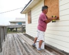
Living along the Gulf coast means knowing the drill when a tropical system approaches. Shuttering windows with plywood, taping glass, and securing loose patio furniture become second nature. Yet, when a storm like Isaias hits this late in October, complacency becomes a massive hazard. People assume that because autumn has settled in, the threat of destructive tropical weather has passed.
That mindset creates a dangerous blind spot.
Isaias didn't just bring wind; it threatened severe water hazards. Meteorologists projected anywhere from 75mm to 150mm of rainfall, with isolated pockets potentially seeing up to 250mm. That kind of deluge spells immediate trouble for drainage networks, leading straight to flash flooding and dangerous river surges across parts of the Florida panhandle, southern Alabama, and Mississippi.
Emergency management officials scrambled to issue hurricane warnings and urgent evacuation orders. When you're facing life-threatening storm surges combined with hurricane-force winds, waiting until the last minute isn't an option. Power grids in these regions faced severe threats of multi-day outages, reminding everyone that infrastructure vulnerabilities remain a constant headache during severe weather events.
Beyond the Gulf Coast: A Global Weather Whip
If you think extreme weather is only happening in your backyard, take a wider look at the planet right now. Weather anomalies are stacking up globally, proving that regional climate systems are acting erratically.
Take Zimbabwe, for instance. While the US Gulf coast braced for Isaias, the southeast Masvingo province declared a state of disaster following a brutal, unseasonal hailstorm. Preliminary reports showed over 8,500 households completely stripped of their roofs, while another 15,300 homes suffered shattered windows. Critical power infrastructure took a massive hit, knocking out sanitation and drainage networks right on the doorstep of the rainy season.
Meanwhile, down under in Australia, residents in Ulladulla—roughly 140 miles south of Sydney—witnessed a rare tornado tear through the town. Tornadoes down there aren't entirely unheard of, with about fifty reports annually, but watching one rip through property and knock down mature trees reminds locals that freak meteorological events are truly everywhere.
How to Prepare When the Forecast Breaks the Rules
When historical records break, traditional preparation checklists need an upgrade. You can't rely on "business as usual" mentalities when climate baselines shift beneath your feet.
- Audit your emergency supplies right now. Don't wait for a warning alert to check your flashlights, batteries, and non-perishable food stocks.
- Know your exact flood risk. Heavy rain bands don't care if you live miles inland. Flash floods catch coastal and interior residents off guard with alarming frequency.
- Stay plugged into local emergency channels. When storms strengthen faster than expected—just like Isaias did—official real-time updates are your absolute best line of defense.
The 2026 Atlantic hurricane season proved that nature loves to defy expectations. Keep your guard up, respect the water, and never assume a late-season calendar date means you're safe.