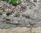
A mountain did not just fall; it vanished. When a massive chunk of ice and rock broke loose along the Nepal-Tibet border, it didn't trigger the tectonic earthquake people feared. Instead, it set off a terrifying, high-velocity debris surge that turned peaceful river valleys into muddy graves in a matter of minutes.
If you look past the initial panic, this disaster reveals a brutal reality about how fragile high-altitude communities have become. You are looking at a system failure where modern infrastructure, warming climate trends, and sudden geomorphic triggers collide.
The Myth of the Sudden Earthquake
When sensors first picked up a violent tremor near Langtang Lirung, scientists and politicians pointed straight to an earthquake. It makes sense. The Himalayas are an active tectonic zone where the earth shakes routinely. Officials in Kathmandu initially blamed a subterranean jolt for fracturing the landscape.
They were wrong. The United States Geological Survey (USGS) analyzed long-period seismic waves and set the record straight: no tectonic fault slipped. The seismic signature registered as a magnitude 5.2 event because a massive slice of a glacier—roughly 2,000 feet wide—dropped thousands of feet down a sheer mountain face.
Think about the sheer physics involved. An ice avalanche of that magnitude generates kinetic energy equivalent to a moderate earthquake just by hitting the ground. The sheer velocity of the impact flash-melted tons of ice, combining with mud and debris to form an unstoppable wave.
Why the Valleys Had No Defense
Water levels in rivers like the Trishuli and Bhote Koshi didn't rise gradually. They spiked by nearly 30 feet in less than half an hour. People were opening shops, children were walking to school, and tourists were heading out on treks when the wall of water hit.
Whole settlements like Timure and Syafrubesi were practically wiped off the map. Bridges vanished, roads dissolved, and vital hydropower projects were smashed into scrap metal.
The cross-border Gyirong Port area, a bustling corridor for trade and tourism between China and Nepal, took a direct hit. Surveillance footage from the Chinese side showed multi-story buildings being swallowed by dark, churning slurry as residents scrambled for higher ground.
The human toll is staggering. With over 160 confirmed deaths and hundreds more missing—including international tourists, pilgrims heading to Mount Kailash, and local residents—search and rescue teams face an impossible terrain. Helicopters drone over choked riverbeds, but thick mud and destroyed access routes make ground rescue agonizingly slow.
The Climate Reality We Keep Ignoring
We keep treating these events as black-swan anomalies. They aren't.
Mountain geography in High Mountain Asia is changing faster than our safety protocols can adapt. Rising global temperatures destabilize permafrost and weaken hanging glaciers. When an ice-rock avalanche blocks a narrow gorge like the Lhende Khola, it creates a ticking time bomb. The temporary natural dam pools millions of gallons of water until the pressure becomes too great, resulting in a catastrophic blowout downstream.
We saw a similar warning shot last year when a glacial outburst triggered severe flooding in the same corridor. Yet, construction of hydropower dams and tourist infrastructure continues deep inside vulnerable river corridors without adequate early warning sensors tied directly to automated evacuation alarms.
Building roads and power plants in active mountain zones requires anticipating that the mountains themselves are falling apart. Traditional concrete defenses mean nothing when an entire mountainside liquefies.
What Needs to Change Right Now
If local governments and international agencies want to stop writing obituaries after every monsoon season, the strategy has to shift from disaster response to predictive engineering.
- Deploy satellite radar monitoring: Real-time interferometric radar can track creeping surface deformation on high-altitude glaciers long before they break.
- Install acoustic flow monitors: Riverbeds prone to ice-rock avalanches need localized acoustic sensors that trigger downstream sirens instantly, buying minutes that save lives.
- Halt high-risk riverside development: Planners must stop zoning permanent commercial structures and labor camps inside narrow, high-velocity flood channels.
The Himalayas are talking. Ignoring the slope stability crisis won't keep the water back.