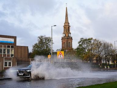
Just when southern England started sweeping up the debris from Friday's weather chaos, a second meteorological punch slammed straight into the country.
Storm Boelo didn't just knock on the door. It kicked it off the hinges. While Storm Austen targeted the south at the end of the workweek, Boelo shifted its fierce focus upward. Scotland, Northern Ireland, and northern England bore the absolute brunt of the assault, facing wind gusts exceeding 80 mph and widespread infrastructure paralysis.
If you live in the UK, this weekend felt less like autumn and more like an endurance test. Here is what actually happened on the ground, why the north got hit so hard, and what the immediate aftermath looks like for travelers and homeowners alike.
The Double-Tap Weather Pattern
The Met Office had warned everyone, but reality still hits harder than a forecast graphic on a evening news broadcast. Storm Austen made its presence known on Friday by battering the south of England—even collapsing a section of Brighton's historic West Pier.
You'd think the atmosphere would take a breather. It didn't.
Instead, Storm Boelo swept in immediately afterward. The system capitalized on strong pressure gradients, driving intense winds and heavy rain across the northern half of the British Isles. The Met Office issued amber wind warnings—their second-highest alert level—covering Scotland, Northern Ireland, and parts of northern England through late Sunday.
Gusts topped 80 mph (128 kph) in exposed areas like the island of Tiree in the Inner Hebrides. When winds cross that threshold, you aren't just looking at knocked-over wheelie bins. You're dealing with structural damage, flying roof tiles, and genuine danger to life from falling debris.
Travel Chaos and Grid Failures
Transport networks across the affected regions ground to a screeching halt. Rail operators urged passengers not to travel as fallen trees and wind-blown obstacles blocked tracks. Ferries across Scottish waters were tied up or cancelled entirely, stranding travelers and cutting off island communities. Airports reported rolling delays and flight cancellations as crosswinds made landings hazardous.
Power networks took a massive hit, too. Energy companies like Scottish and Southern Electricity Networks (SSEN) scrambled to respond to dozens of unplanned outages within hours of the storm's peak. Thousands of homes across Scotland lost power as overhead lines snapped under the strain of howling gales and flying branches.
Meanwhile, cleanup crews down south were still dealing with the tail end of Storm Austen. The National Grid reported that power had been restored to more than 130,000 properties affected by Austen by Saturday evening, only for energy technicians in the north to pivot directly to fighting Boelo's outages.
Why Naming Storms Matters
It's easy to roll your eyes at every new storm name thrown around by forecasters. Every season feels packed with dramatic titles. But the Met Office's naming system, established back in 2015, serves a very practical purpose.
When storms are tracked alphabetically from September to August, emergency services can coordinate responses faster, and the public takes warnings more seriously. Calling a system "Storm Boelo" instead of just "a windy weekend" changes how people behave. It keeps folks indoors, clears the roads, and ultimately prevents injuries.
Beyond British Shores
Britain wasn't the only place caught in the crosshairs. The same weather system didn't stop at the North Sea. Heavy rain and severe winds battered parts of Norway, Sweden, and Denmark throughout Sunday.
Ferry cancellations disrupted Scandinavian routes, train lines were suspended as a precaution, and authorities in Denmark barred certain high-sided trailers from crossing the massive Great Belt Bridge. When a jet stream gets this active, northern Europe feels the squeeze all at once.
Next Steps for Residents
If you're in the affected zones, don't rush outside the second the wind drops a notch. Hidden structural damage, loose roof slates, and downed power lines continue to pose serious risks long after the eye of the storm passes. Check your property carefully, report any damaged utility lines immediately, and keep an eye on local transport updates before attempting any long journeys as schedules recover from the weekend's wreckage.