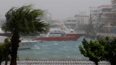
When a Category 5-equivalent monster storms through the Pacific, hitting the history books before it even touches the mainland, you know the old playbook is dead. Typhoon Bavi is not just another bad storm hitting China's eastern coast right after Typhoon Maysak. It is a stark warning that our baseline for severe weather has fundamentally shifted.
If you are looking at the headlines about hundreds of thousands of people evacuating Zhejiang province, you might think this is standard procedure for a region used to rough summers. It isn't. The sheer speed at which Bavi exploded from a weak tropical depression into a terrifying 285 km/h violent typhoon in early July has caught regional forecasters off guard. China had barely finished clearing the debris from Maysak before raising its emergency responses to the highest levels.
The real story here isn't just that a storm is coming. It is how an overstretched infrastructure copes when disasters stack up without a breathing room.
The Nightmare of Back to Back Landfalls
Most coastal cities can handle a big storm. You board up windows, stack sandbags, clear the drainage systems, and ride it out. But what happens when the ground is already completely saturated?
That's the reality facing eastern China right now. Typhoon Maysak left a trail of saturated soil, swollen rivers, and compromised infrastructure. When Typhoon Bavi charted its path toward Zhejiang and Fujian provinces, it targeted a coastline that was already deeply vulnerable.
The numbers are staggering. Chinese authorities had to scramble to evacuate well over one million people ahead of Bavi's landfall near Yuhuan, Taizhou. In Wenzhou, emergency crews worked through the night to pull people from low-lying areas. It's a logistical nightmare. Evacuating a million people once is a massive undertaking. Doing it twice in a single week creates intense public fatigue and stretches local rescue resources to a breaking point.
The Trajectory of a Historic Monster
Bavi did not start out looking like a historic anomaly, but it quickly became one.
- June 30: Formed as a weak disturbance near Kwajalein.
- July 2: Upgraded to a tropical storm, benefiting from exceptionally warm sea surface temperatures of up to 30°C.
- July 3: Underwent explosive intensification, jumping from 80 mph to a jaw-dropping 145 mph winds in just 18 hours.
- July 6: Screamed past Rota in the Northern Mariana Islands at peak intensity, packing 1-minute sustained winds of 285 km/h.
By the time Bavi spun through the Ryukyu Islands of Japan and whipped northern Taiwan with heavy rains, it had already left a trail of destruction behind it.
The Domino Effect Across the Region
To understand why Bavi is driving emergency planners crazy, you have to look at the collateral damage it caused before even reaching China. This wasn't a localized event. It was a regional catastrophe.
In the Philippines, Bavi didn't even make direct landfall, yet its outer bands triggered devastating flash floods and landslides. The storm took at least 17 lives there. The worst part? In places like Sarangani, the torrential rain hit soil that had already been destabilized by a major earthquake earlier in the year. The ground simply gave way, burying homes in minutes.
Further north, the remote islands of Japan and the coastal towns of Taiwan faced 12-meter waves. Taiwan's defense ministry had to put roughly 29,000 soldiers on standby. When locals in Keelung started taping up windows and hoarding food, they weren't being paranoid. They were looking at a system that was breaking records for raw power.
Typhoon Bavi Peak Intensity Metrics:
- 1-Minute Sustained Winds: 285 km/h (180 mph)
- Lowest Central Pressure: 901 hPa
- Classification: Category 5-equivalent Super Typhoon
Why the Old Disaster Infrastructure is Failing
Honestly, we need to talk about why these storms are suddenly behaving like this. Meteorologists point to a dangerous mix of record-high ocean temperatures and incredibly low wind shear. Basically, the Pacific Ocean acted like an open buffet of energy for Bavi.
When a storm undergoes rapid intensification, it cuts down the warning time for local governments. You go from planning for a moderate tropical storm to fleeing a super typhoon in less than a day. China has spent billions of dollars on sophisticated flood defenses, sea walls, and early warning systems over the last decade. But those systems were designed around historical models. They didn't account for back-to-back typhoons of this scale hitting the exact same stretch of coastline within days of each other.
When Bavi made its second landfall in Zhejiang, its maximum sustained winds had slowed down to around 89 mph, but the wind speed wasn't the primary threat. The real danger lies in the colossal volume of water it carried. A weakening typhoon can still drop a meter of rain on an area where the riverbanks are already bursting.
What Happens Next
The immediate threat of Bavi's wind will pass as the storm moves northwestward inland and loses its punch, but the danger won't end there. If you live in or monitor these vulnerable coastal zones, the next 48 hours require strict vigilance.
First, stay completely clear of mountain slopes and known floodplains in Zhejiang and surrounding provinces. Landslides don't always happen during the peak of the storm. They often occur hours or days later as water logs the deep soil layers.
Second, local communities must treat every municipal flood warning with absolute seriousness, even if the rain seems to be letting up. Runoff from higher elevations will continue to feed into urban drainage systems long after the eye of the storm has dissipated. The recovery from this double-hit week will take months, and the lessons learned from Bavi will undoubtedly force a complete overhaul of how East Asia prepares for an increasingly volatile typhoon season.